High pressure is the dominant force for the UK’s weather at present, though parts of western Scotland and Northern Ireland will have a more unsettled afternoon on Monday.
Elsewhere, heat will build in the coming days, with good amounts of sunshine for many.
Met Office Chief Meteorologist Frank Saunders said: “Much of the UK is entering a warm or even hot interlude of weather, with some places in England and Wales likely to meet heatwave criteria in the coming days.
“Temperatures are likely to peak at around 32C in southeast England on Tuesday and Wednesday, with much of the UK experiencing dry, fine and warm conditions in the first half of the week.”
The UK Health Security Agency, which looks specifically at potential impacts on the health and social care sector, has issued a Yellow Heat Health Alert for parts of England.
UV levels are likely to be high for many in the coming days. Find advice on steps you can take to manage UV and its effect on health. Further advice from expert organisations on making the most of summer weather is also available as part of WeatherReady.
What is a heatwave?
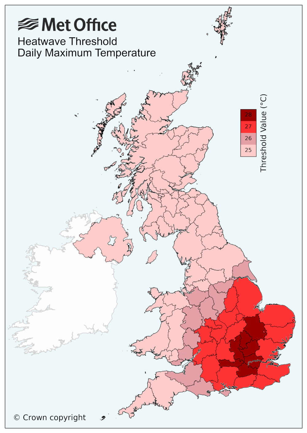
An official heatwave has occurred when a specific temperature threshold is met or exceeded for three consecutive days. The threshold varies by UK county, as shown in the UK temperature threshold map below.

Thundery breakdown to come
While warmth will remain for many on Wednesday, there’s a chance of some thundery showers developing in southern areas for a time, before a more widely unsettled day on Thursday with some potentially impactful thunderstorms at times.
A Met Office warning for thunderstorms has been issued from Thursday afternoon, highlighting potential disruption to travel, as well as the chance of some flooding where thundery outbreaks merge.
⚠️ Yellow weather warning issued ⚠️
Thunderstorm warning across much and England and parts of Wales
Thursday 1200 – 2359
Latest info 👉 https://t.co/QwDLMfRBfs
Stay #WeatherAware⚠️ pic.twitter.com/Vov6OnDRFr
— Met Office (@metoffice) July 29, 2024
Met Office Deputy Chief Meteorologist David Oliver said: “There’s a chance of some thundery showers across some southern areas of England on Wednesday, then on Thursday there is a signal for some potentially very heavy thunderstorms to develop. There are still details to confirm during this period, but in any event there is a chance of some impacts on each day, especially Thursday.
“The heaviest showers on Thursday could result in 20-30mm of rain within an hour, with daily totals possibly reaching as high as 90mm if multiple showers impact the same location. Lightning and hail present additional hazards, with disruption likely for some. This is a developing element of the forecast, so it’s important to stay up-to-date with the latest outlook in the coming days.”
Thursday’s thundery breakdown heralds a shift to a more unsettled weather regime for the UK later in the week and into the weekend, with a westerly weather regime likely to bring outbreaks of rain at times, albeit with some drier interludes.
You can find the latest forecast on our website, on YouTube by following us, on Twitter and Facebook, as well as on our mobile app which is available for iPhone from the App store and for Android from the Google Play store.


